In 1996, President Clinton made a bold and controversial move, declaring 1.9 million acres of land in southern Utah a National Monument. The designation turned almost the entire southern portion of the state - already heavy with National Parks - into Federal land. The monument was to be bordered on the East by Capitol Reef National Park and the Glen Canyon National Recreation Area (aka Lake Powell), on the North by the Dixie National Forest, on the South by the Vermillion Cliffs National Monument and Paria - Vermillion Cliffs Wilderness Area, and on the West (at least halfway) by Bryce Canyon. Some gaps remained for population centers, but at a pen stroke Clinton created the country's largest National Monument - and made the locals and Utah state officials furious. The locals fought with (continue to fight with?) the Federal government for control of the area, including claiming ownership of roads within the monument and challenging the President's authority to designate such a large area of land as a monument.
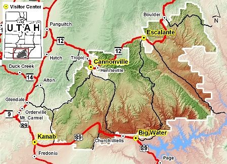 Or you can use the very large PDF map
Because the land had some development within it, and in part because they were already familiar with the land, Clinton assigned management of the monument to the BLM - the first monument to be managed under their care. If you visit, you'll likely notice some differences between management of this monument and others you may have been to; the BLM is slowly learning the ropes, but it's been a bit of an uphill climb. Many of the locals seem to be adapting to the designation these days; the increase in tourism, especially in the towns of Boulder and Escalante, has helped to ease the sting somewhat.
Follow along below the squiggle for a more in-depth tour of this crown jewel in the rough of our National Monument system - Grand Staircase - Escalante.
As you might have guessed by the name, Grand Staircase - Escalante National Monument protects and highlights several geographic features within its boundaries. Because each of these areas are relatively isolated travel-wise, I'll describe them separately here...
The Grand Staircase
The Grand Staircase is a series of cliffs laid out roughly South to North in order of ascending height. Each exposes a different geologic layer of rock, and each has a distinct coloration from which the cliff takes its name.
Lowest of the layers are the Chocolate Cliffs. Within the monument, these cliffs are found on the very southern edge, running in to the Paria - Vermillion Cliffs Wilderness and Glen Canyon and generally south of U.S. 89, the main road that runs near the southern border of the monument.
Next up the chain are the distinctive and tall reddish sandstones of the Vermillion Cliffs. These cliffs are prominent as you drive along U.S. 89, and are the sometime home for the re-introduced California Condor. The beauty and uniqueness of these cliffs is apparent from the fact that no fewer than three separate Federal lands protect them.
Above and to the north of the Vermillion Cliffs lie the White Cliffs. The rock formation exposed by the White Cliffs is called the Temple Cap, and is most famously visible as the white rock seen in many of Zion National Park's formations. Within GSENM, the cliffs are most distinct in the area of Skutumpah Road and Johnson Canyon - dirt roads that travel the western border of the monument, skirting eventually up near Bryce Canyon.
Above the White Cliffs lie the Gray Cliffs. As with the White Cliffs, the rock formation responsible for the Gray Cliffs - the Straight Cliffs formation - is most visible outside of the Grand Staircase area. The Straight Cliffs form the eastern edge of the next region in my summary - the Kaiparowits Plateau - and are most visible from the Escalante section of the monument.
Finally, at the top of the heap are the Pink Cliffs. This beautiful sandstone is famously carved into the amphitheaters of Bryce Canyon, and also makes up the stone of the Aquarius Plateau which lies within Dixie National Forest just north of the monument.
The main road through this area of the park is the Cottonwood Road - a generally well-maintained dirt road that leaves U.S. 89 in the south between the Paria Ranger Station and the small town of Church Wells, and travels north to Utah Scenic Byway 12 and the town of Cannonville just outside of Bryce Canyon. If the road is in good shape (and it's usually a passenger car rated road), it is a spectacular drive with some good highlights along the way. Near Cannonville is Kodachrome Basin State Park, which hosts some interesting stone pillars. Also along the road you can see the towering Grosvenor Arch, the beautifully jumbled rock area called Candyland, the ridge of The Cockscomb, and you can get out of the car and hike a number of narrow canyons.
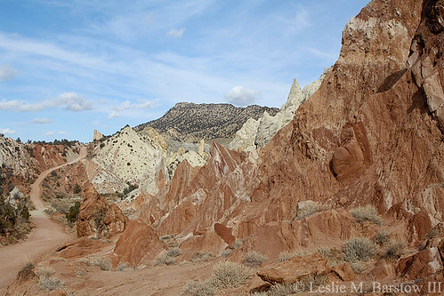 Candyland
The Kaiparowits Plateau
I won't spend a lot of time on the Kaiparowits. It is perhaps the single most remote region in Utah, crossed by a couple of (normally poorly maintained) dirt roads and without any modern human habitation. It is a land of eroded canyons and mineral resources - a coal mine had been planned up on the plateau, but it was halted in its tracks when Clinton designated the monument - one more reason the locals disliked the decision. The Kaiparowits is bounded in the South by the Vermillion Cliffs and in the East by the Straight Cliffs; just to the West of it lies the Cottonwood Road.
The Canyons of the Escalante River
This area of Grand Staircase - Escalante is almost certainly its main attraction. East of the Kaiparowits Plateau lies the extensive drainage of the Escalante River with its seemingly infinite array of tributaries and sporadic washes. The Escalante is perhaps the largest tributary drainage leading to Glen Canyon (the main source of water for which is the Colorado River), but it is the side canyons leading toward the Escalante which make this place special.
The main road leading in to this area is the extremely variable dirt road called the Hole-in-the-Rock Road, which departs the town of Escalante heading parallel to the river on its way to Glen Canyon. The first part of the road is usually okay, but it can deteriorate severely the further you drive it. It's probably best to detail this area of the monument in pictures rather than in words - a thousand words might not do the place justice.
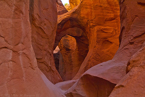
This first area is called Devil's Garden Outstanding Natural Area. It has a picnic area, and you can often find children exploring the formations. (I tend to cringe when I see too many kids not being very careful; some of the rock formations look to be quite fragile...)
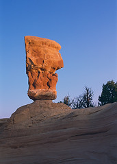
A Hoodoo at Devil's Garden
|
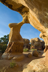
Metate Arch
|
Beyond the Devil's Garden, most of the oustanding areas along the Hole-in-the-Rock Road are hikes to spectacular canyon scenery. Here you will find the best collection of slot canyons to be found outside of the Antelope Canyon area near Page, AZ. And because the monument is much less populated than Page, you're more likely to have a slot canyon to yourself for long enough to take some good pictures...
 Peekaboo Canyon
There are too many hikes to beautiful places for me to detail here, ranging from short hikes to slot canyons to multi-day hikes through the larger canyons like Coyote Gulch or Death Hollow. If you want to make an adventure hiking to some of these and other scenes, I highly suggest picking up a guide book to the area. Because I'm a photographer, I tend to like "Photographing the Southwest, vol. 1" by Laurent Martrès; technical canyoneers might try something like "Canyon Hiker's Guide to the Colorado Plateau" by Michael Kelsey.
Scenic Byway 12 and the Burr Trail
Utah Scenic Byway 12 travels along the northern border of Grand Staircase - Escalante National Monument, occasionally slipping into the Dixie National Forest for a scenic detour. Cutting off from it in the town of Boulder, reaching the far northeastern portion of the monument, is an historic cattle trail (now road) called the Burr Trail, which leads into some of the more remote sections of Capitol Reef National Park. Yes, these roads rate their own section - really.
The Burr Trail offers access (via the Wolverine Loop Road) to the eastern drainage of the Escalante River, including Horse Canyon and the narrows of Little Death Hollow, but its main attraction is the road itself, winding up through the red walls of Long Canyon and eventually coming out at the top of the ridge leading down into the Waterpocket Fold and Capitol Reef National Park. Along the way is an Outstanding Natural Area and a small side canyon that can be quite scenic while being easy to reach for most tourists (not handicap accessible, though...)
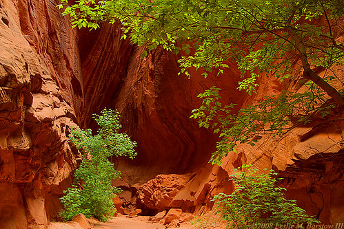 Slot canyon along the Burr Trail
Scenic Byway 12 is rated as an All-American Road and is one of the most scenic roads I have ever driven. It's also a bit scary in spots...
 The Hogback along UT Scenic Byway 12, by vtveen
The portion of the road traveling from Boulder to Escalante provides access to a number of features within the Escalante River drainage including access to the Escalante itself, which you can hike in-river between the two towns if you'd like. Rugged desert rock scenery surrounds you along the road, and if you have an eye for that kind of scene you can oggle it for hours and never grow tired of the intricate rock erosion patterns, canyons, hills and knobs. One stopping place of note along the road is the very nice hike to Calf Creek Falls, which offers a nice cool destination to what could otherwise be a very warm hike.
Some Final Words
Before wrapping it up for the Park Avenue group, of which this diary has been a service, I would like to throw in a few notes about visiting this remote and relatively undeveloped area. Aside from U.S. 89 and UT Scenic Byway 12, all roads in the monument are dirt. As with any dirt road in Utah, do not travel them if you think they'll be wet - Bentonite clay outcrops are common in the region, and when wet they will absolutely bog down your vehicle and potentially disable it. Be sure to ask at the visitor center about the condition of roads you're thinking of traveling; I have been on both the Hole-in-the-Rock and Cottonwood roads when they've been bad, and you do not want to ruin a car or even a light SUV or stock SUV on them when they're truly in disrepair. Finally, take plenty of water wherever you go - it's the desert, after all.
Now for a word from our sponsor. This is yet another diary in the Park Avenue series on our National Parks and Monuments. For other diaries in this series (as well as more travel oriented diaries for our public lands, and diaries on some of our state parks), please visit the Park Avenue blog page.
We are looking for diary writers! We do not currently have much of a backlog for future park diaries and we need some help. If you want to contribute to this exploration of our wonderful public lands, please contact me (Phoenix Rising) by leaving me a message, or contact the Park Avenue group with a message.
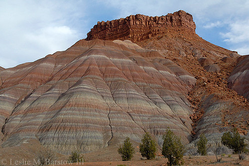 Colorful hillside near the Paria townsite
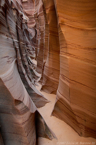 Zebra Slot near Escalante
